Dhaka, a region at risk
Good and bad flooding in one of the largest deltas on earth
Text: Braun, Boris, Köln
Dhaka, a region at risk
Good and bad flooding in one of the largest deltas on earth
Text: Braun, Boris, Köln
Kolkata and Dhaka are among those cities that are most severely threatened by global warming. But because of their location in the Ganges Delta the cities are already now regularly hit by flooding. People in Dhaka are most severely hit; while the old city sits on a raised fluvial terrace, almost 50 percent of the inhabitants live currently in low-lying former wetlands. On average, many dwellings of the poor are flooded every 4 years for several weeks. How can people who already live near the minimum subsistence level cope with such extreme conditions without government support?
The densely populated lowland of Bengal is among those regions in the world that are most severely hit by extreme natural disasters. Time and again, the river delta formed by the Ganges, Brahmaputra, and Meghna is hit by extensive flooding. But earthquakes and devastating tropical cyclones do also frequently occur. What makes the lowland of Bengal such a distinct risk region? What does this mean for the people living there? And which precautions are being taken against the danger of flooding?
The drainage area of the three rivers comprises more than 1.5 million square kilometres; the region sees the highest precipitation amount on earth, especially in the Meghalaya Hills to the Northeast of the Bengal alluvial plain. The Cherrapunji meteorological station for example, which is known worldwide, registers a long-term median of more than 11,000mm rainfall per year (by comparison, in Berlin the value is close to 600mm, in Frankfurt around 650mm). As this mass of water must be led to the Bay of Bengal over a relatively small area, the rivers regularly burst their banks during the summer monsoon from June to September. In the process, Bangladesh has to cope with water masses from rainfall in an area that is 12 times wider than the country.
Moreover, particularly in April and May as well as in October and November, tropical cyclones arise over the Bay of Bengal that then move toward the Northeast. Kolkata, which lies near the coast, is more immediately threatened by these cyclones and the concomitant storm tides than Dhaka. But the repercussions are felt indirectly in Dhaka as people from the hit coastal regions move into the city.
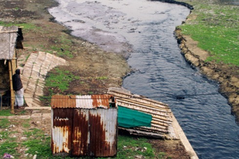
As in Bengal as a whole, Dhaka’s topography is flat. The old city prudently had been built in a raised fluvial terrace, but since the 1970s the city has outgrown the edges of the terraces in several directions. Thus, Dhaka today lies between 1 and 12 metres over sea level, and two thirds of the city’s area less than 5 metres over it. Especially slums but also new business and apartment districts are encroaching in low-lying areas or are directly built at the edge of rivers and streams (see also p. 36). Roughly half of the population live on former wetlands that are particularly prone to flooding.
Although Dhaka is located somewhat off the great rivers, the city is surrounded on all sides by smaller streams. And if the water level of the Brahmaputra, Ganges and Meghna is high, the smaller streams cannot discharge their water; along a wide front, it disgorges in settled areas. A further problem that causes flooding is the water-surface ascent by “water logging” which means that the waste water system is clogged by unregulated garbage disposal and is thus unable to dispose of the heavy rainfall during the summer monsoon. For a long time, polyethylene shopping bags had been the main problem until they were banned in 2002.
Too much water – too little water
Not only do flooding disasters in Bengal occur frequently, but their extent is almost unimaginable from a European perspective. In the course of the last 60 years, a clear trend towards more severe flooding has not been registered – although this has often been conjectured in the context of global warming. The long-term, relatively stable figure is that, in summer, around 20 percent of Bangladesh’s land area is flooded at the maximum. However, the differences between drier and wetter years have become more extreme – a difficult development as not only too much, but also too little water leads to disastrous consequences. For the rural population, flooding is vital because it guarantees soil moisture up to the dry season in winter and because the mud that is brought to the fields improves the soil fertility. For that reason, flooding of up to 20 percent of the land area in Bangladesh is called “barsha” (good flooding) while disastrous, “bad” flooding is called “bonna”.
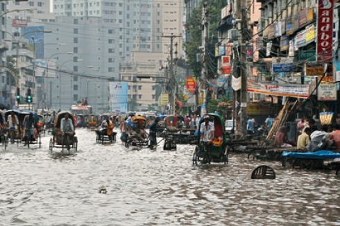
The most severe catastrophe in recent history occurred in 1998 when more than two thirds of Bangladesh’s land area were flooded for more than 6 weeks. In Dhaka, the impact of the 1988 flood had been most devastating; 150 people died during this disaster when more than 85 percent of the city stood up to 4.5 metres under water. This traumatic incident triggered off a large-scale upgrading of the technical protection facilities. Up to then, there had only been a short reinforcement bank between the Buriganga and the historic city that been erected in the 19th century. After the catastrophe a levee measuring around 30 kilometres in length was raised west of the city. In the result, an area of about 136 square kilometres is now relatively well protected, at least from water that is intruding from outside. But the eastern part is, for the most part, still without any protection; plans from the 1990s to also erect a levee there have as yet not materialised.
However, the activities did not concentrate on constructional measures alone; after the 1988 trauma the flood early-warning system that had been installed in 1972 was also upgraded. During the once-in-a-century flood of 1998 the system helped to prevent a worse course of the disaster; however, the limits of technological flooding prevention and flooding management also became manifest. In 1998, nearly the complete eastern part of Dhaka and about 20 percent of the western districts stood several metres under water. Roughly 262,000 residential buildings were partly or completely destroyed, two thirds of which had been primitive huts. More than 2 million people had to leave their homes. The roughly 300 emergency shelters were completely overcrowded, and parts of the poorer population became homeless for several weeks.
Coping strategies of the slum dwellers
An inquiry led by the author in collaboration with geographer Tibor Aßheuer in 2009 among slum dwellers in Dhaka has shown that flooding is a well-known, regular phenomenon for the people living in these settlements. Apart from the rather shorter “water logging” occurrences, every 4 years on average they have to cope with floods during which the water is standing several decimetres or even metres high in their living quarters for more than 2 weeks. In this case, the people at first try to stay in their huts or on their roofs and to protect their furniture and valuables by piled-up brick “towers”. If these measures prove insufficient they seek help in emergency shelters, in the accommodations of friends and relatives, in unfinished multi-storey buildings, on embankments or at the side of higher-lying streets. As a rule, in such cases the heads of the household cannot do any gainful work for several weeks. As many slum dwellers work in the informal sector or as day labourers, every lost day means pecuniary injuries. Thus in many cases hunger, disastrous sanitary conditions, contaminated drinking water and disease arise as consequences.
In order to preserve or to reconstruct their basis of life, most households stricken by the disaster depend on loans given by neighbours, NGOs or informal, local moneylenders. Repayment of these loans, together with the often high interest rates, is a substantial burden. However, the people show remarkable abilities to cope with such dramatic situations and recover rather quickly – partly due to the fact that they are integrated into social networks that as a rule are functioning quite well. Financial and material help comes not only from the families but also from neighbours, from better-off land and house owners or employers. Thus, social capital is an important resource in negotiating flooding and other external shocks.
People show an admirable ability to adapt to changed conditions and to devise flexible problem solutions. So, roughly 70 percent of the people said that within 2 months after the retreat of the water the essential repairs in their dwellings had been carried out and they had returned to their everyday routine. Most households were also able to replace destroyed or lost goods; 29 percent of the people could achieve this within one month, and 87 percent within 6 months. Nearly two thirds of the interviewed households had paid back their loans within a year.
From the point of view of the official disaster management and with respect to prevention measures it seems sensible to use and to specifically encourage the considerable potentials of the existing social networks. Nevertheless, the people’s enormous creativity and their improvisation skills must not hide the fact that while individual persons can survive in such conditions they have hardly any chances for socioeconomic advancement and permanent risk minimisation.
Translation from German by Christian Rochow


0 Kommentare